 0 items
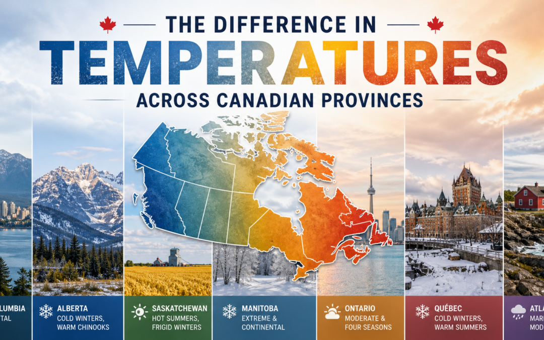
Canada is often imagined as a uniformly cold country, but that stereotype quickly falls apart when you look at the wide range of temperatures across its provinces. Stretching from the Pacific Ocean to the Atlantic, and deep into the Arctic, Canada’s geography creates dramatic climate differences. These variations influence not just weather patterns, but also lifestyle, economy, and even cultural identity in each province. Understanding these temperature differences reveals a more nuanced picture of the country.
On the west coast, British Columbia stands out as one of the warmest regions in Canada, particularly along its southern coastline. Cities like Vancouver and Victoria benefit from the moderating influence of the Pacific Ocean. Winters here are relatively mild, with temperatures often staying above freezing, while summers are warm but rarely extreme. However, this coastal mildness contrasts sharply with the interior of the province. Places like Kamloops or Prince George experience a more continental climate, with colder winters and hotter summers. This contrast within a single province highlights how geography—mountains, oceans, and elevation—can shape temperature patterns.
Moving eastward, Alberta presents a very different climate profile. Known for its proximity to the Rocky Mountains, Alberta experiences significant temperature swings. Winters can be extremely cold, especially in northern areas, with temperatures dropping well below -20°C. However, a unique feature of Alberta’s climate is the Chinook winds—warm, dry winds that can cause temperatures to rise dramatically within hours during the winter. Summers, on the other hand, are generally warm and sunny, particularly in southern regions like Calgary and Medicine Hat. Compared to British Columbia’s coastal stability, Alberta’s climate is far more variable.
Saskatchewan and Manitoba, located in the Prairie region, are known for some of the most extreme temperature ranges in Canada. These provinces lack large bodies of water or mountain ranges to moderate the climate, resulting in hot summers and very cold winters. In Saskatchewan, summer temperatures can exceed 30°C, while winter temperatures often plunge below -30°C. Manitoba, particularly in cities like Winnipeg, is famous for its harsh winters and humid summers. The continental climate here creates some of the largest seasonal temperature differences in the country.
Ontario, Canada’s most populous province, has a more moderate climate compared to the Prairies, but still experiences significant variation. Southern Ontario, including cities like Toronto and Ottawa, benefits from the Great Lakes, which help regulate temperatures. Winters are cold but not as extreme as in Manitoba, and summers are warm and often humid. Northern Ontario, however, tells a different story. Temperatures there can be much colder in winter, with shorter, cooler summers. This north-south divide within Ontario demonstrates how latitude plays a key role in temperature differences.
Quebec shares some similarities with Ontario but tends to experience colder winters overall, especially in its northern regions. Montreal and Quebec City have cold, snowy winters and warm summers, but as you move further north, temperatures drop significantly, and the climate becomes subarctic. The vast size of Quebec means it encompasses multiple climate zones, from humid continental in the south to Arctic conditions in the far north. This diversity makes Quebec one of the most climatically varied provinces in Canada.
In Atlantic Canada—comprising New Brunswick, Nova Scotia, Prince Edward Island, and Newfoundland and Labrador—the ocean plays a dominant role in shaping temperatures. These provinces generally have cooler summers and milder winters compared to inland regions at similar latitudes. However, Newfoundland and Labrador stands out for its variability. Coastal areas are influenced by cold ocean currents, leading to cool summers and relatively moderate winters, while Labrador experiences much colder, more Arctic-like conditions. The maritime climate also brings more precipitation and frequent weather changes.
Finally, while not provinces but territories, it’s worth noting the northern regions—Yukon, Northwest Territories, and Nunavut—for context. These areas experience some of the coldest temperatures in Canada, with long, harsh winters and very short, cool summers. In some parts of Nunavut, temperatures can remain below freezing for most of the year. Compared to the provinces, these regions highlight the extreme end of Canada’s climate spectrum.
Overall, the differences in temperature across Canadian provinces are shaped by a combination of latitude, proximity to oceans, elevation, and local geography. Coastal provinces tend to have milder, more stable climates, while inland provinces experience greater extremes. Northern regions are significantly colder than southern ones, reflecting the country’s vast size and geographic diversity.
These temperature variations are more than just a matter of weather—they influence agriculture, infrastructure, and daily life. For example, farmers in the Prairies must contend with short growing seasons and temperature extremes, while those in southern Ontario benefit from longer, warmer summers. Similarly, heating costs, clothing choices, and even recreational activities differ widely across provinces.
In conclusion, Canada’s climate is far from uniform. Each province has its own distinct temperature patterns, shaped by geography and environmental factors. From the mild, rainy winters of British Columbia to the frigid cold of Manitoba and the variable maritime climate of Atlantic Canada, these differences contribute to the rich diversity of life across the country. Understanding them not only challenges common stereotypes but also offers insight into how Canadians adapt to and thrive in such varied conditions.